Hovdsundet is located just north of the city of Bodø, which is especially known for its ferry connections to the Lofoten Islands. The trailhead is only about 20 kilometers from the city center, making it easily accessible, and the road leading there is a well-maintained paved road.
Hovdsundet Hike
Distance: 6,5 kilometers round trip
Difficulty: Moderate
Starting Point: Google Maps
Elevation Gain: 112 meters
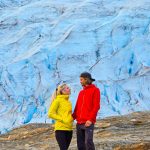
Scenery: Coastal cliffs, a stunning sandbar nestled between cliffs, and panoramic views of the Lofoten mountain range
Parking and getting to the trailhead
Getting to the starting point of the hike is quite straightforward. From Bodø, head north and turn off toward the villages of Valvika / Mulstrand in the direction of Mjelle. The trailhead is located on the left-hand side of the road, about 1,5 kilometers after the turn. There’s no formal parking lot at the trailhead itself, but there’s space for maybe one or two small cars. If you continue a few hundred meters further, you’ll find a larger parking area on the right side of the road, where parking is much easier.
If you’d like to have a snack break either before or after the hike, continuing a bit further from the trailhead’s parking area will take you to a pleasant and free parking/rest area called Mjelle parkeringsplass. It features several picnic tables set in beautiful coastal surroundings, making it an ideal spot for enjoying some food. It’s definitely worth checking out these views either before or after your hike.


The trail
The trail starts by skirting along the edge of a property, initially passing through a lightly wooded area and then crossing a field towards the coast. Since this is Norway, you might see sheep grazing in the neighboring field right from the start. The distance from the trailhead to the beach is about 700 meters.
The trail isn’t formally marked, but using an app like AllTrails makes it easy to stay on the recommended and well-worn path. That said, you can also reach the destination simply by following the coastline, so it’s entirely doable without any aids. Towards the end, it’s worth cutting slightly inland from the shoreline to shorten the distance a bit.
A wonderfully quiet beach for camping
The trail follows close to the shoreline for much of the way, offering breathtaking views throughout the hike. Free-roaming sheep are a common sight, and the terrain alternates between meadow paths and rocky outcrops.
About 1,5 kilometers into the hike, you’ll reach a beautiful sandy beach that seems to serve as a great camping spot. A few groups were there enjoying the evening and setting up tents. There was still plenty of space, so if you’re looking for a good place to camp, this is a strong recommendation. Behind the beach is a flat grassy area with enough room and privacy for tents.
Off the beach lies a fairly large rocky islet, which adds a nice touch to the already picturesque scenery.
We continued on from here and, just beyond the next cove, reached a slightly rockier beach. However, the sea has shaped the rocks over time into beautifully smooth and rounded forms.
Up until this point, the trail had been very easy to walk, but from here on out, it started to include a few more challenging sections that required a bit of climbing or effort.


Navigating ravines and the trail’s final — and only — ascent
The only real ascent of the hike occurs in this final stretch, with the last 700–800 meters gradually climbing upwards. While the trail is still unmarked, it’s fairly easy to see where others have walked, as the worn rock surfaces help guide you in the right direction.
There are a few spots that require taking small leaps across rock gaps, and the most nerve-wracking part is encountering a somewhat dubious-looking bridge between two cliff ledges. The short bridge appeared somewhat decayed and didn’t seem firmly attached to anything, raising a few doubts about whether to trust it. But in the end, it held up perfectly and showed no signs of instability.


A Surprise at the finish – A stunning beach and views of the Lofoten Mountains
These more challenging parts are all in the early stages of the ascent. After that, you climb steadily over solid and relatively even rock. Reaching the top is truly surprising and rewarding, as you don’t see the main view—or even a hint of it—until the very end. The landscape opens up suddenly as you reach the edge of the cliff, and it can only be described as truly unique. A pale sandy strip lies nestled between two steep-sided cliffs, and beyond that, the dramatic peaks of the Lofoten mountain range rise in the distance. It’s a view worth admiring for a long while.
We had a traditional snack break here and watched the sun set behind the mountains of Lofoten, which made the scene absolutely magical. We were on a night hike, and since it was late July, the sun actually dipped below the horizon. The trail was extremely peaceful at this time of night—aside from a few campers on the beach, we didn’t see anyone else on the trail.


Strong Recommendation for the Hovdsundet Trail
The Hovdsundet hike absolutely deserves a strong recommendation. The scenery at the end is incredibly beautiful and unique—especially at sunset! The trail is also relatively light and easy, with very little elevation gain, except for the final stretch that includes some slightly challenging spots where agility helps. It’s also good to pay attention to where the most sensible route goes in these sections. Overall, it’s an easy and rewarding hike in the Bodø region and a perfect addition to your list of things to do in Bodø!